I like to believe that there isn’t a whole lot that escapes me, especially when it’s something this painfully obvious. But as reader Brian Neal has helpfully pointed out, I managed to miss a real whopper here.
Using Google Earth’s historical imagery – which I’ve utilized once before in order to demonstrate that the claims surrounding the school’s parking lot are total bunk – we are able to spot a number of clear, irrefutable signs that Sandy Hook Elementary School was (as always) open and completely operational. Of course this shouldn’t come as much of a surprise to those of you who have been paying attention, honestly contemplating the available information and stacking it up against the abhorrent and outrageous claims made by serial con-men like Jimmy Fetzer and Wolfgang Halbig, both of which still continue to claim that the school was permanently shuttered in 2008, despite a total lack of supporting evidence. But what’s different this time around is that the source – satellite imagery from Google – is much, much more difficult for these disingenuous clowns to simply hand-wave away. Whereas these hucksters have dismissed evidence from The Newtown Bee, The Newtown Patch, and other local media outlets due to their proximity to and relationship with the school, what outrageous excuse will they dream up for these images? Will they accuse Google of being complicit in their alleged hoax, widening the circle of co-conspirators even further? Will they claim that these photos – freely available to all, via Google Earth – have magically and secretly been “Photoshopped”? Or will they simply ignore them altogether, choosing instead to invent more lies and launch yet another fundraiser?
First, let’s look at the satellite view of Sandy Hook School, taken in August of 2010 (note the date in the upper-left):

Now compare that with the following, taken in March of 2012:

Ignoring the area beyond the school’s grounds, there are at least six fairly obvious differences here, which I’ve marked below, using the image taken in 2012:

Let’s take a closer look at each one:
#1: The addition of a basketball/four square/hopscotch court:

Located next to the expansion building, which housed most of the school’s fourth grade classrooms, we can view this court up-close in the crime scene photos (specifically Gunsalus – exterior photos.pdf):

While the goofy ideas and baseless claims scattered throughout James Fetzer’s abysmal “Nobody Died At Sandy Hook” make very little sense and are often at odds with one another, the theory that the school was closed in 2008, used as storage, and then staged at a later date – approximately October of 2012, according to Allan Powell – is a constant. And with that in mind, the fact that this court appeared sometime in between August of 2010 and March of 2012 – seven months before the building was allegedly set up to resemble a real, working school – doesn’t fit very neatly into their narrative.
#2: A bustling outdoor playground:

While the photo on the left – taken during the students’ summer vacation – shows a quiet, empty playground, the one on the right shows it full of children during a recess period. Obviously it doesn’t make a whole lot of sense for a group of children to be playing at an abandoned school, especially one deniers have claimed is dangerously infested with asbestos.
#3: Differing table configurations in the courtyard:

Here we see the tables located in the courtyard area have been moved. While it would be odd enough that multiple tables remained two years after they allegedly closed the school, it would be infinitely more so if the said tables were continually being moved around, four years after the fact. There also appears to be an additional object in the small seating area – located in the lower right-hand side of the photo – that Dawn Hochsprung would use to read (as the “Book Fairy”) to students, as seen in this image taken from her Twitter feed:

#4: The addition of a shed and storage container:

Located behind the school, this shed and storage container can be seen on the very left of the following photo, taken from the same set of crime scene photos (Gunsalus – exterior photos.pdf) as the basketball court:

Why would a condemned school need to a shed and storage container, years after closing their doors for good? To store all of the extra asbestos that clowns like Maria Hsia Chang falsely claim was pouring out of the school? Clearly there’s a much simpler answer here: this was a normal, functional (if not a bit dated) elementary school, and they needed more room.
#5: A revitalized field:
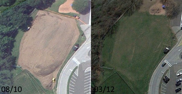
Looking at the photo taken in August of 2010, it’s incredibly obvious (you can even make out a yellow bulldozer towards the bottom) that they were in the process of revitalizing the large field located on the east side of the school. Why spend that kind of money re-doing such a large swath of land if no one has seen it or will see it for years to come? And why spend even more money by continuing to maintain it? It makes zero sense.
But we don’t even need to entertain such tall tales, as we know that this area was frequently used by the school for activities, such as the 2012 Turkey Trot:

#6: Re-painted fire lanes:

We’re actually able to narrow down the completion of this work even further, using the following photo from The Newtown Fund’s Depot Day 2011, which took place on December 17th:

As the lines do not appear in this photo, we know that they must have been painted somewhere in between December 17th, 2011, and March of 2012. If Sandy Hook deniers like Fetzer and Halbig are correct (and make no mistake, they are most certainly not), then the school would have been closed for over three years before someone decided to finally get around to painting those lines in the fire zone. The idea is thoroughly preposterous; a shining example of just how poorly constructed and porous the entire denier narrative is. Normally, work this shoddy would embarrass even the most amateur of sleuths, but this type of flagrant deception has blossomed into a very lucrative, six figure a year occupation for people like Halbig, who have spent their lives as nobodies, struggling to be a somebody to someone… anyone, even if it means the prolonged torture of the people of Newtown.
Again, a big “thank you” is in order to Brian Neal, who pointed these differences out to me elsewhere on the site. It’s honestly a bit embarrassing to have missed something so glaring, especially having looked at these images a number of times, but hey, at least someone caught it.
For more in the “Sandy Hook Elementary Was Open” series, please read:
Part One: The Lobby
Part Two: The Obstinate Pen
Part Three: Holiday Decorations And Calendars
Part Four: SMART Technologies
Part Five: Dawn Hochsprung’s Twitter Feed
Part Six: The 2011-2012 Scrapbook
Part Seven: Children’s Authors Visit Sandy Hook
Part Eight: Charitable Causes
Part Nine: The Library
Part Ten: 92 More Photos From Sandy Hook School
Part Eleven: Over 195 Articles Referencing Sandy Hook School, Written Between 2008-2012
Part Twelve: The Glass Display Cases
Part Thirteen: Google Earth
Part Fourteen: The November 2012 Scholastic Book Fair
Part Fifteen: Sandy Hook School Enrollment For 2008-2017
Part Sixteen: School Documents From 2008-2012
a few months late ,but you are very welcome
there’s satellite photo proof that the courtyard was renovated in 2010
I never noticed the different table configurations before. The first or second thing I noticed were the newly painted lines throughout the parking lot and in front of the school. Brian is slipping, he’s sharp and I first encountered him about 01 2014. Compare google earth to the helicopter videos from that tragic day, why would there be recent crack sealing all over the parking lot if the school was closed? I looked in the Bee for photos from SHE and never found any. I knew some had to be there…Just like you know the words exist in a crossword puzzle. Finding them here is kind of annoying. I found out a long time ago that telling hoaxers to look on google earth for proof of the school being open was as hopeless as trying to teach a bird to fly backwards.
Forgot about this…if you look on google maps you can see school buses lined up in front of the Sandy Hook school. I tried to find the date the satellite photo was taken and there is a way to find the date because I googled it and it explained how…it was just a bit over my head cause I’m not current on tech stuff. Perhaps you could take a look and get back to me on the date the buses were in front of the school. Thanks.
I don’t believe I’ve seen the buses. Can you link the view you’re speaking of?
I first found the images on a u tube hoax video. I’ve looked but can’t find how to go back to view old google map satellite images, they’ve updated them and I tried to discover if old ones can be viewed but haven’t had any luck. There must be a way?
There’s a web site called HISTORIC AERIALS .COM , that shows that over half of the school was built after 1991,,, btw your site wouldn’t let me post the link
Thanks. Not sure why the URL was blocked. I was under the impression that I was allowing links from approved commenters. I’ll have to look into it.
Unsurprisingly, the aerial from 2012 shows a packed parking lot. I don’t believe that this is the same 2012 aerial photo available via Google Earth. That means that there are at least two aerial photos of the school taken in 2012, and both show a busy parking lot, which would awfully strange for a school that was allegedly closed two years earlier. But I’m sure some disingenuous goon will simply claim that the lot was staged in anticipation of these satellite photos being taken.
I believe both views are on the same day google was in the morning ,and the web site was in the afternoon , looking at the white vehicles in the google view , most match up with the white vehicles in the other view.
I think you’re right in regards to the day. The shadow on the historicaerials.com leads me to believe it was taken sometime around 11AM or so (using findmyshadow.com as a guide) while the Google satellite photo was taken closer to 3PM. This make sense as there are fewer cars in the lot in the Google photo, which would be activity consistent with an elementary school.
i see what you mean , i guess i shouldn’t analyze shadows when i’m tired . , I kinda got my directions mixed up.